
Instant PDF Planning Map for UK Applications
A planning application can be held up by something surprisingly simple: the wrong map scale, an unclear red line or mapping that is not licensed for planning use.
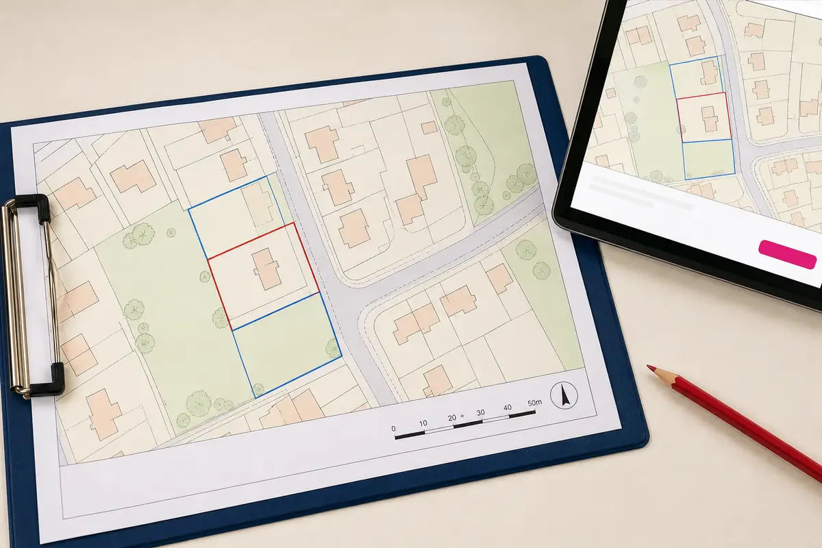
An instant PDF planning map helps you avoid that wait. Once you have found the property, chosen the scale and marked the boundary, you can place your order and download the finished plan straight away.
Whether you are a homeowner planning an extension, a landowner applying for a change of use or an architect dealing with several applications, speed is only part of the job. The map must also be suitable for the local planning authority, at the correct scale and clearly marked.
What an instant PDF planning map should include
Most UK planning applications need a location plan. This shows the site in relation to surrounding roads, buildings and other recognisable features, so the planning officer can identify it easily.
A location plan is normally drawn at 1:1250 or 1:2500 scale, with the application site outlined in red. Other nearby land you own may need to be outlined in blue.
You may also need a site plan, sometimes called a block plan. Usually drawn at 1:200 or 1:500, it gives a closer view of the property. It may need to show existing buildings, the proposed work, access, parking, gardens, neighbouring properties, roads, rights of way, trees and boundaries.
The exact requirements vary, so it is always worth looking at your local planning authority’s validation checklist before submitting the application.
A good instant PDF planning map should have a clear scale, north point, licensed mapping, recognisable surroundings and easy-to-see boundary lines. It must also be readable at its intended size. A fast download is no help if the labels are unclear when printed.
Why the source of planning mapping matters
A planning map is not simply a screenshot from an online map service. A screenshot may look fine on screen but lack the scale, licence details or clarity needed for a planning application.
Professional planning plans are generally based on licensed Ordnance Survey mapping, providing a dependable base with roads, buildings, boundaries and place names that can be used in an application.
The scale needs to suit the site. A 1:2500 location plan covers a wider area and works well for rural or larger sites. For an average property in a built-up area, 1:1250 often gives a better balance of detail and context.
For a rear extension, driveway, garage or small outbuilding, you may also need a 1:500 or 1:200 site plan. Check your council’s guidance before ordering.
How to create your map without slowing down the application
Making a planning map should be straightforward, but a little care at each stage can save a validation query later.
Start by finding the correct property or land. You should be able to search by postcode, address or coordinates, or find the site on an interactive map. This is especially useful for woodland, agricultural land and plots without a postal address.
Next, choose the plan type and scale. If you are unsure, look at the validation requirements on your local authority’s website. These often explain whether you need a location plan, a site plan or both. Although 1:1250 is common in built-up areas, always check it suits your application.
Draw the red line carefully around the application site. Include all land forming part of the proposal, such as a new access, parking space, garden area or drainage feature. Do not include neighbouring land simply to make the site easier to spot.
The boundary should agree with the site description and your other drawings. If the proposal includes a new road access, for example, make sure it sits inside the red line.
Show adjoining land you own in blue where required. This can be overlooked when a house, garden, garage plot and access are under the same ownership but only part is included.
Before paying, check the preview. Make sure the whole site is within the map, the red line does not hide important details and the north point is visible. Include enough surrounding roads or buildings to identify the property, and check the scale once more. It takes less than a minute.
These are real problems people come to us with. One customer found that his location map did not show enough of the surrounding area or neighbouring properties. After he phoned us, we added the extra detail and emailed him a revised version.
Another customer accidentally ordered a plan without the red boundary. He called, we corrected it and sent the plan again with the red line in place. It is exactly why we encourage people to check the preview and to get in touch if something has gone wrong.
With UK Planning Maps, the finished PDF is available as soon as your purchase is complete, with no wait for manual preparation. This is useful when you are assembling an application that day or working to a deadline. Always open and check the final PDF before uploading it to the Planning Portal.
Choose the plan type for the job
A location plan and a site plan do different jobs, and many applications need both. If you only provide one when the council expects two, it may ask for the missing plan before it will validate your application. On the other hand, there is no point paying for a more detailed plan if it is not needed.
For a householder extension, a 1:1250 location plan and a 1:500 site plan are often a sensible starting point. The location plan shows the property within the street and surrounding area. The site plan gives a closer view and can show the extension in relation to the house, boundaries, access and parking.
For a larger development or a change of use, the best scale will depend on the size and setting of the land. A 1:2500 location plan may be more suitable for fields, rural land or a large site on the edge of a settlement. A separate 1:500 plan can then show the site layout more clearly.
Some proposals need more than planning mapping. If your application involves detailed design, drainage, levels, contours or engineering work, you may need drawings or reports prepared by a suitably qualified professional as well.
Architects and designers who want to add information, coordinate a map with other drawings or use it as a base for design work may prefer CAD mapping files. A PDF is a convenient choice when you need a finished plan for printing or submitting. CAD mapping files offer more flexibility, but you will need suitable software and an understanding of the relevant technical and licensing requirements.
Avoid the common causes of map rejection
Local planning authorities do not all ask for exactly the same things, so no map provider can promise that every application will be accepted without a question. However, most mapping problems are avoidable. Use current, licensed mapping, choose a recognised scale, mark the site clearly and follow the council’s validation checklist for your type of application.
Pay particular attention to the red boundary. It should not stop halfway along a proposed access or leave out land that is needed for the work. Equally, it should not include extra land simply because the applicant owns it.
If the ownership or boundary position is complicated, or the site involves leasehold land or rights of way, it may be better to ask a planning professional or solicitor for advice.
Always check the finished PDF rather than relying only on the editor preview. Open it at a normal viewing size and make sure the text, boundaries and surrounding features are easy to read.
If you plan to send in a paper copy, print a test page at 100%. Do not select “fit to page” or another setting that changes the scale.
Fast does not have to mean rushed
The real benefit of an instant download is that you stay in control. You can create the map when it suits you, download it straight away and add it to the rest of your planning documents without waiting for a manual service.
With prices starting from £8.50, it is also an affordable way to get the right plan rather than trying to make an unsuitable screenshot work.
It is still worth spending an extra minute checking the scale and boundary. A clear, properly prepared map helps the planning officer understand the site straight away and gives your application the best chance of moving through validation without an unnecessary hold-up.
Ready to Get Your OS Plans?
Every plan is instantly downloadable, Planning Portal‑compliant, and includes all required elements. Get your plan now and submit your application with confidence.