
How to Draw a Red Line Boundary on a Location Plan
The red line on a location plan identifies the land included in a planning application.
It should normally include the application site and all land needed to carry out the proposed development.
This can include the property, garden, access, parking, landscaping and other land connected with the application.
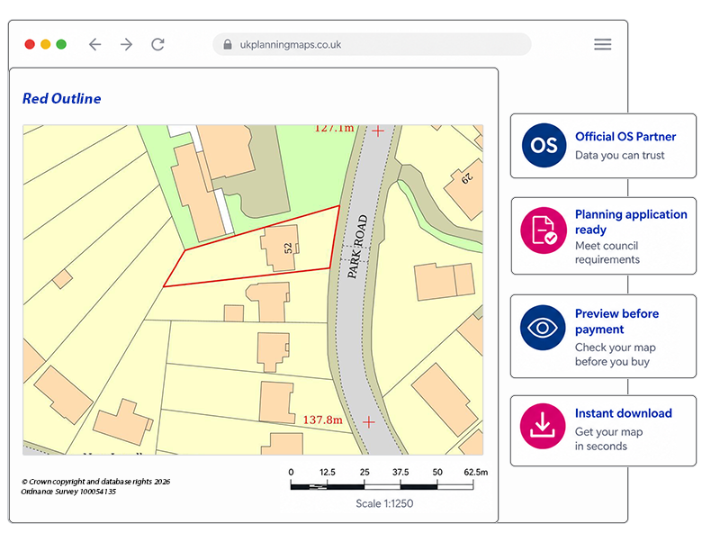
What is a red line boundary?
The red line is a continuous line drawn around the main planning application site.
It tells the Local Planning Authority:
- Which land the application relates to
- Which buildings are included
- How the site is accessed
- What area should be considered when assessing the development
There should normally be one complete red boundary.
The red line should be easy to see and should form a closed shape around the application site.
What should be included inside the red line?
The red line should normally include all land needed for the proposed development.
Depending on the application, this may include:
- The existing house or building
- The proposed extension or new building
- Front, side and rear gardens
- Driveways
- Access tracks
- Parking areas
- Turning areas
- Visibility splays
- Landscaping
- Open land around buildings
- Garages and outbuildings
- Land connecting the site to the public highway
Do not draw the boundary around only the part of the site where building work will take place unless that genuinely represents the full application site.
The postcode does not define the boundary
Entering a postcode helps you find the correct map.
It does not decide which land should be included in the application.
The red line is drawn separately and should be based on the land connected with the proposed development.
This is particularly important for:
- Large gardens
- Properties with separate garages
- Shared driveways
- Farms
- Rural plots
- Properties containing several buildings
- Sites with more than one postal address
Red line example: house extension
For a normal extension to a house, the red line will often follow the boundary of the whole residential property.
This may include:
- The house
- Front garden
- Rear garden
- Side garden
- Driveway
- Garage
- Access to the road
The red line should not normally be drawn tightly around only the proposed extension.
The exact shape and dimensions of the extension will normally be shown on the block plan, floor plans and elevations.
Red line example: new house in a large garden
Where a new house is proposed within part of a large garden, the red line should include all land forming part of the application.
This could include:
- The new house plot
- Its garden
- The proposed driveway
- Parking and turning space
- Landscaping
- Visibility splays
- Access to the public road
The rest of the original property may need to be shown in blue if it remains in the applicant’s ownership but is outside the application site.
Red line example: shared driveway
If the application site uses a shared driveway, the part of the access needed to reach the public road may need to be included within the red boundary.
The red line can extend along the access without including every neighbouring property that also uses it.
Ownership and access rights can be complicated. Where you are unsure about the land that should be included, seek advice from the Local Planning Authority or a planning professional.
Red line example: rural development
For a rural development, the red line may need to include:
- The proposed building
- The yard or working area
- Parking
- Turning space
- Landscaping
- The access track
- The junction with the public road
It does not necessarily need to include every field or every part of the farm.
Other nearby land owned by the applicant can be outlined in blue.
Red line example: visibility splays
A visibility splay is an area that must remain clear so drivers can see approaching traffic when leaving a driveway or road junction.
Where visibility splays form part of the proposal, the land may need to be included within the red application boundary.
This can be important where the splay extends outside the main property entrance or across adjoining land.
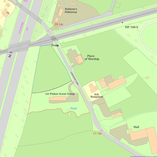
Example Red Outline for Location Plan - House Extension
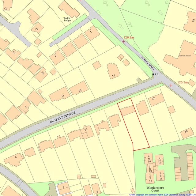
Example Red Outline for Location Plan -
new house in a large garden
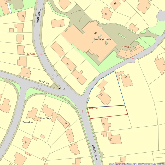
Example Red Outline for Location Plan - Shared Driveway
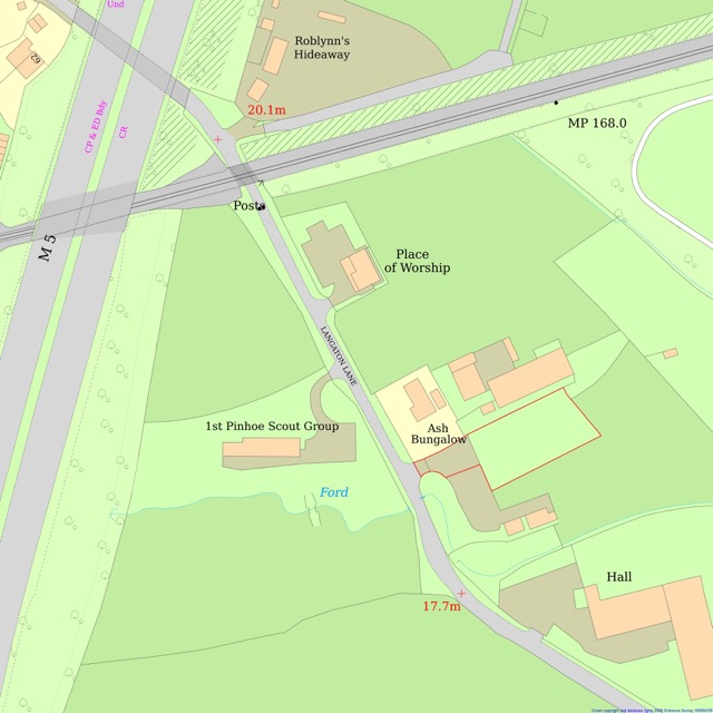
Example Red Outline for Location Plan - House Extension
How to draw the red line
1. Find the site
Enter the postcode or use our Advanced Search to find the location.
2. Check the whole site is visible
Make sure the property, development area and access can all be seen on the plan.
3. Start at a clear point
Choose a corner or recognisable boundary feature.
4. Follow the site boundary
Click around the edge of the application site.
Include the access and other land needed for the development.
5. Close the boundary
Return to the starting point so the red line forms a complete shape.
6. Review the plan
Check that the line:
- Is continuous
- Is easy to see
- Does not cross through buildings accidentally
- Includes the correct access
- Matches the application form and other plans
What is the blue line boundary?
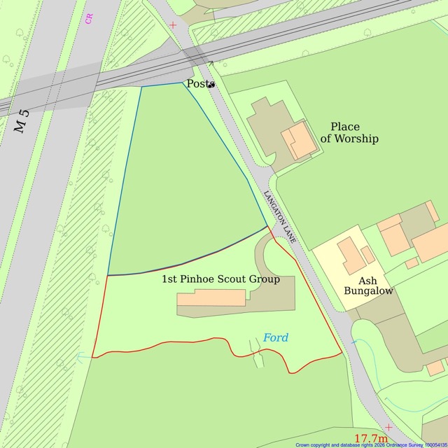
A blue line is used to identify other nearby or adjoining land owned by the applicant that is outside the red application site.
For example, the applicant may own:
- An adjoining field
- A neighbouring house
- A separate garage plot
- Another part of an estate
- Nearby woodland
There may be no blue boundary, one blue boundary or several separate blue boundaries.
Do not use blue to show land owned by somebody else.
Is the red line a legal boundary?
The planning red line is not, by itself, proof of the exact legal ownership boundary.
It identifies the land covered by the planning application.
Ordnance Survey mapping records physical features on the ground. It does not determine the exact legal ownership boundary.
A Land Registry title plan also normally shows general boundaries rather than the exact legal line.
Where there is a boundary dispute, uncertain ownership or a complicated access arrangement, obtain professional advice.
Common red line mistakes
Drawing around only the proposed building
The red line normally identifies the application site, not only the footprint of the proposed work.
Leaving out the access
The site may need to be connected to the public highway within the red boundary.
Leaving gaps in the line
The red boundary should form a clear, closed shape.
Including land owned by somebody else without explanation
Only include land that is genuinely part of or needed for the application.
Using blue for the application site
The main application site should be outlined in red. Blue is for other nearby land owned by the applicant.
Using a title-plan boundary without checking it
A title plan has a different purpose and does not automatically define the correct planning application site.
Check your boundary before ordering
Ask the following questions:
- Does the red line show the whole application site?
- Is the driveway or access included?
- Is the connection to the public road clear?
- Are parking and turning areas included where required?
- Is other nearby land owned by the applicant shown in blue?
- Does the red line match the application form?
- Does the block plan show the same application site?
- Is the complete boundary visible at the selected scale?
View our location plan examples to see acceptable and incorrect boundaries.
Create your plan now
Use UK Planning Maps to draw the red and blue boundaries and download your completed plan.
Standard location plans start from £13.
Trade Account customers receive 15% off every product, reducing the starting location-plan price to £11.05.
Need help? Call 01856 898 022.
Example of Blue Line Boundary showing other land owned.
Frequently Asked Questions
Ready to Get Your Location Plan?
Every plan is instantly downloadable, Planning Portal‑compliant, and includes all required elements. Get your plan now and submit your application with confidence.