
What Maps Do Councils Accept for Planning?
A planning application can be delayed before anyone considers the design if the map does not clearly show where the proposal is. So, what maps do councils accept? Most UK planning authorities expect a correctly scaled, up-to-date location plan and, where needed, a more detailed site or block plan. The exact checklist varies by council and application type, but the basic rules are consistent.
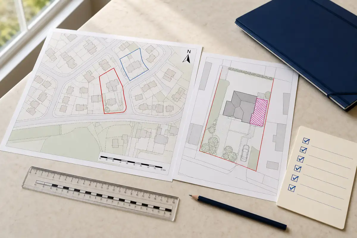
It is easy to assume that any clear map will do for a planning application. In practice, councils need a plan that identifies the correct land, uses a suitable scale and contains the details on their current validation list. It must also agree with the application form and other drawings.
What Maps Do Councils Accept?
There is no single map specification used for every application. National guidance cited here applies to England; Wales and Scotland have devolved planning systems, and local requirements vary. Different application types may need different plans.
Most applications require a location plan. It places the site among surrounding roads or landscape so an unfamiliar reader can find it. The plan normally shows a north point, stated scale, recognisable roads and buildings, and a clear red line around the application site. Our location plan definition explains its purpose in more detail.
Many applications also need a site plan, often called a block plan. This is a closer view showing how the proposal relates to the existing building, boundaries, access and neighbouring land. The proposed work may need to be added separately because the mapping base records existing mapped features, not an extension or building that has not yet been constructed.
The safest answer to “what maps do councils accept?” is therefore: the plans listed by the relevant authority, at a suitable scale and with the requested information. Check its current validation list before submitting.
The Details That Make a Plan Acceptable
A planning map must first show the correct place. Compare the address, building shapes, road names and access rather than relying only on a postcode pin. This is especially important for rural land, new plots and properties sharing a postcode.
The red line should include all land needed for the proposal. That may include the building, garden, access from the public highway, visibility splay, parking, landscaping or drainage land, depending on the application. It should not be drawn only around the proposed building footprint or automatically around every piece of land owned by the applicant. The red line boundary guide covers the usual approach.
Other nearby or adjoining land owned by the applicant may need a blue line when it sits outside the application site. Blue records wider ownership; it does not bring that land into the proposal. If ownership or a shared access is uncertain, check the title information or take appropriate advice, as a mapped line does not prove a legal boundary.
The plan should also carry a north point and clear scale information. A linear scale bar is useful and may be required locally. Boundaries need to be visible without hiding road names, buildings or other details needed to identify the site.
Why Licensed Mapping Matters
Councils need mapping that can be used for its intended purpose. An online-map screenshot, estate agent's plan or old drawing may lack dependable scale, current detail, suitable reproduction rights, a north point or enough surrounding context.
Current, accurately scaled Ordnance Survey mapping licensed for planning use is a common planning base in Great Britain. It is not universally mandatory; applicants should follow the authority's wording. UK Planning Maps provides plans for England, Scotland and Wales, not Northern Ireland.
In England and Wales, an HM Land Registry title plan helps identify registered land, but it is not a permitted substitute for a planning location plan. Title plans also show general boundaries rather than deciding the precise legal line.
Copyright and licence details should remain on the finished plan. Licensed mapping still needs the correct boundary, scale and proposal information added. It supplies the base; it does not by itself make the complete planning submission valid or guarantee planning permission.
Location Plan Scale: 1:1250 or 1:2500?
A 1:1250 location plan is a common choice for a house or smaller site in a built-up area. At that scale, 1 centimetre on the plan represents 12.5 metres on the ground. It usually gives enough surrounding streets and buildings without making the application site too small.
A 1:2500 plan covers a wider area, with 1 centimetre representing 25 metres. It can work better for a rural property, a large site or land set back from the public road. The extra coverage is useful only if the red line remains clear and the site can still be identified.
These are typical scales, not automatic rules. Check the requested paper size as well as the ratio, and make sure the whole site fits. Printing with “fit to page” can alter the scale, so use the intended sheet size and print at 100% or actual size.
When You Need a 1:500 or 1:200 Site Plan
A location plan answers “where is it?” A site plan or block plan answers “how does the proposal sit on the site?” Councils commonly ask for the closer plan when the relationship with boundaries, neighbouring buildings, access, parking or gardens needs to be understood.
At 1:500, 1 centimetre represents 5 metres. This often gives a useful view of the house, plot and immediate surroundings. At the technically larger and more detailed 1:200 scale, 1 centimetre represents 2 metres. It can suit an extension, new outbuilding or work close to a boundary, although it covers less ground. Some authorities request 1:100 or 1:200 for particular householder block plans, so do not select the scale by habit.
Depending on the proposal, the site plan may need existing and proposed buildings, boundary treatments, access, parking, trees, hard surfaces, rights of way or drainage features. The guide to 1:200 block plan requirements gives a closer look at this more detailed option.
Common Reasons Councils Reject or Query Maps
A map problem normally leads to a validation query or an invalid application, not a refusal of planning permission. Small issues can still prompt a request for a replacement plan.
A frequent issue is the wrong plan type. A close site plan may not contain enough wider context to locate the property, while a location plan may not show how the development relates to the plot. Submit both when the validation list asks for both.
Boundary errors also cause questions. The red line may stop short of the access, surround only the new building, cross the wrong property or be hidden by a heavy line. A blue line may be missing where the requirements call for nearby owned land to be shown, or used where there is no relevant additional ownership.
Other problems include an unsuitable scale, a crop that cuts off part of the site, no north point, unclear labels, old mapping, missing copyright information or a PDF that was resized after creation. The location, orientation and proposal should also agree with the floor plans, elevations, application form and ownership certificate.
One customer's experience shows why it is worth checking the requirement rather than guessing. In Mrs Dawson's review, she said a DIY location plan had not met the council's requirements. An online chat helped establish what was needed, and a replacement arrived within minutes; she reported that the council verified it the following day. That was her individual experience, not a promise that another plan will be validated or approved.
A Practical Check Before You Submit
Start with the local authority's current validation list for the application type. Note whether it asks for a location plan, site or block plan, particular scale, paper size and any proposal-specific details. If the council has already queried a map, use its exact comments rather than simply ordering the same type again.
Before paying, check the preview carefully. Make sure the correct site is centred, the whole relevant application land fits inside the page, the public-road connection is included where needed and the red line remains easy to follow. Add a blue line only when the ownership information calls for it. Keep enough surrounding roads and buildings to identify the site.
PDF is usually the safest finished upload format, but accepted file types and size limits vary. Check the authority's portal and keep the plan legible at its intended sheet size; there is no universal DPI requirement. Use A4 or A3 where possible unless another size is requested. After a completed UK Planning Maps online order, the file is available to download from the website immediately; the email copy can take up to 20 minutes.
Open the actual PDF rather than relying on the preview. Check the address, scale, north point, licence details, boundaries and version date. Compare it with the application form and drawings. If printing, use the intended paper size and actual scale.
Finally, give files clear names such as Location Plan and Proposed Site Plan, then reopen the uploaded copies to make sure the correct versions were attached. A careful map cannot secure approval, but it can remove avoidable uncertainty and give the council the site information it needs to assess the application.
Ready to Get Your OS Plans?
Every plan is instantly downloadable, Planning Portal‑compliant, and includes all required elements. Get your plan now and submit your application with confidence.