
Choosing Planning Map Scales for Your Application
A planning application can be held up by something as basic as using the wrong map scale. A plan may show your site clearly, but if it does not provide the surrounding context or enough on-site detail, the local planning authority may ask for a replacement. Understanding planning map scales before you order helps you submit the right documents first time.
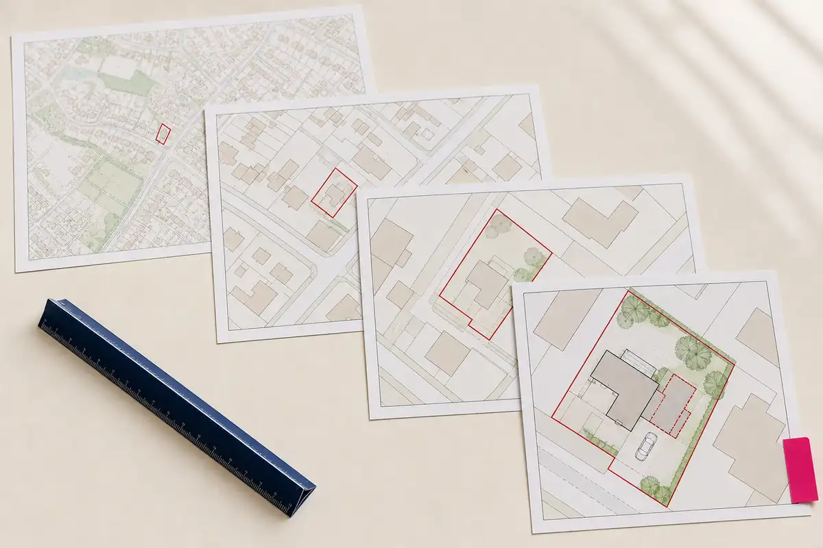
Choosing planning map scales is easier once you know each plan's job. A location plan identifies the site in the wider area; a site plan or block plan gives a closer view. There is no single scale for every planning application, so check which plan, scale and paper size the local authority requests.
What planning map scales mean
A scale relates a distance on the plan to the ground. At 1:1250, one unit on the map represents 1,250 in real life, so 1cm on the printed plan represents 12.5m.
The second number shows how far reality has been reduced. A 1:2500 map covers more ground than 1:1250 on the same sheet. A 1:200 plan shows features larger, but fits in less land.
Technically, 1:200 is the larger, more detailed scale, while 1:2500 gives wider coverage. When ordering, think about the job: wide context for finding the site or close detail for understanding the layout.
The stated scale is reliable only when the PDF is printed as intended. Use the correct paper size and 100% or actual size; “fit to page” can resize it.
Scale is about the relationship between the plan and the ground, not the age or quality of the underlying mapping. The same Ordnance Survey mapping can be presented at several scales. What changes is the area covered and the amount of detail that can be read comfortably on the finished page. A close scale cannot make an inaccurate boundary correct, and a wider scale does not make the mapping less current.
Zooming in on a PDF viewer does not change the scale stated on the plan. It only enlarges the image on screen. The scale becomes especially important when a printed copy is measured, which is why the paper size, print setting and scale bar should all be checked together. If a print has been resized, use a correctly printed copy rather than trying to measure from it.
1:1250 for a typical location plan
A 1:1250 location plan is common for houses, smaller plots and built-up areas. It can show the surrounding street and neighbouring buildings while keeping the red line visible.
Here, 1cm represents 12.5m. This provides useful context for many residential sites without making the property tiny.
The 1:1250 location plan scale guide explains more. It is common, not automatic: a large site or long access may need different coverage, and the authority can request a scale.
Check the preview. The whole application area should fit with recognisable features around it. If the boundary reaches the edge or access disappears, adjust the map.
1:2500 for wider or more rural sites
A 1:2500 location plan covers more ground: 1cm represents 25m. It can suit rural properties, fields, larger sites and plots set back from a named road.
The wider view may show an access track, junction or buildings needed to locate land without a street address. It can also keep a large red line on the page.
On a small plot, 1:2500 may make the red line hard to see. If 1:1250 identifies the site and is accepted, its closer view may be clearer.
For a large or irregular area, bespoke coverage or a larger sheet may be better than squeezing the boundary into the wrong format.
1:500 for a site plan or block plan
A 1:500 site plan or block plan gives a closer view: 1cm represents 5m. It commonly shows a complete property or medium plot with some immediate surroundings.
The plan may show buildings, access, parking, gardens, boundaries and neighbouring properties. Trees, hard surfaces, rights of way, walls or fences may also be relevant.
A 1:500 plan can include more of the plot than 1:200 while keeping the layout readable, perhaps showing a house, garden, driveway and neighbours together.
It does not substitute for a wider location plan or for architectural drawings. Many applications need both map types.
1:200 when closer detail is useful
A 1:200 site plan shows less area in greater detail: 1cm represents 2m. It can suit a compact plot, extension, outbuilding or parking layout.
The closer view clarifies small spaces, access and proposed work. The trade-off is coverage: a long drive, garden or neighbouring feature may fall outside the page.
The 1:200 block plan requirements guide explains typical checks. An authority may instead request 1:100, 1:500 or another scale.
Do not crop out relevant land to keep close detail. A 1:500 plan, larger sheet or additional drawing may work better.
Choose the scale for the project and the site
Start with the plan type. A location plan, commonly 1:1250 or 1:2500, identifies land in the wider area. A site plan or block plan, often 1:500 or 1:200, explains the proposal within the property.
Then consider the site. A terraced house, rural building plot and large field need different coverage. A driveway or public-road route may need to remain visible and sit inside the red line.
The work matters too. An extension near a boundary may need close detail; a change of use over a larger parcel may need broader coverage. Levels, drainage, highways, trees or landscaping can require specialist plans.
For a house extension on a normal street, the location plan might be 1:1250 so the property can be found easily. A separate 1:500 site plan may then show the house, garden, proposed extension and neighbours. If the plot is particularly compact or the work sits close to a boundary, a 1:200 view may be useful where the authority requests or accepts it.
For a rural building plot, 1:2500 may give the location plan enough context to include the road, track and nearby landmarks. The detailed site layout could still be shown separately at 1:500 or 1:200. Using two scales is not duplication: one identifies the land while the other explains the proposal.
For a large development or change of use, standard coverage may not fit the whole red line clearly. A larger paper size or bespoke plan can keep the application boundary, access and surroundings readable. Additional drawings may then show particular parts of the site in more detail. Trying to make one map serve every purpose often produces either too little context or too little detail.
Look at the preview at its intended size. Can somebody unfamiliar locate the site? Are red and blue lines clear? Does the closer plan show the proposal's relationship with boundaries and neighbours?
What the finished plan should show
Content depends on local requirements, but plans commonly need a metric scale, north point and enough features to be understood. Mapping should be clear and suitably licensed.
The red line normally outlines the application land, not simply a building footprint. It may include garden, access, parking, landscaping or drainage land. See the red line boundary guide.
Nearby owned land may need a blue line when outside the site. Blue shows wider ownership; it does not add land to the development. Seek advice if boundaries or ownership are unclear.
Ordnance Survey mapping is a common base because it offers consistent detail and can be suitably licensed. It is not universally mandatory; check what the authority accepts.
Check the local requirements before ordering
Typical scales do not override instructions. UK validation requirements vary by authority, application and site. A council may specify scale, paper size, coverage or detail.
If an application is invalid, follow the authority's replacement request. Check whether it needs a location plan, site plan, block plan or revised file rather than guessing again.
Compare maps with the form, ownership certificate and drawings. Address, red line, building and access should agree throughout.
Create and check the plans simply
Have the address or postcode, plan type, scale and boundary ready. Coordinates or a map search can help with land without an address.
Choose the plan and scale, centre it and check coverage. Draw red carefully, add blue only where required and review location, boundary, surroundings, north and scale.
Open the downloaded PDF and repeat the check. Confirm lines and labels are clear and printing preserves scale. Give each plan a clear filename.
Use the authority's requirements first, then choose the scale that shows the whole site and performs the plan's job. A preview and final PDF check can prevent a simple mapping delay.
Ready to Get Your OS Plans?
Every plan is instantly downloadable, Planning Portal‑compliant, and includes all required elements. Get your plan now and submit your application with confidence.