
Planning Compliance Starts With the Right Map
You can spend weeks getting an extension design right, only to have your application held up by a map. Perhaps the access is missing, the boundary is unclear or the plan has been saved at the wrong size. Planning compliance starts with something quite practical: giving the council a clear picture of where the site is and what land the application covers.
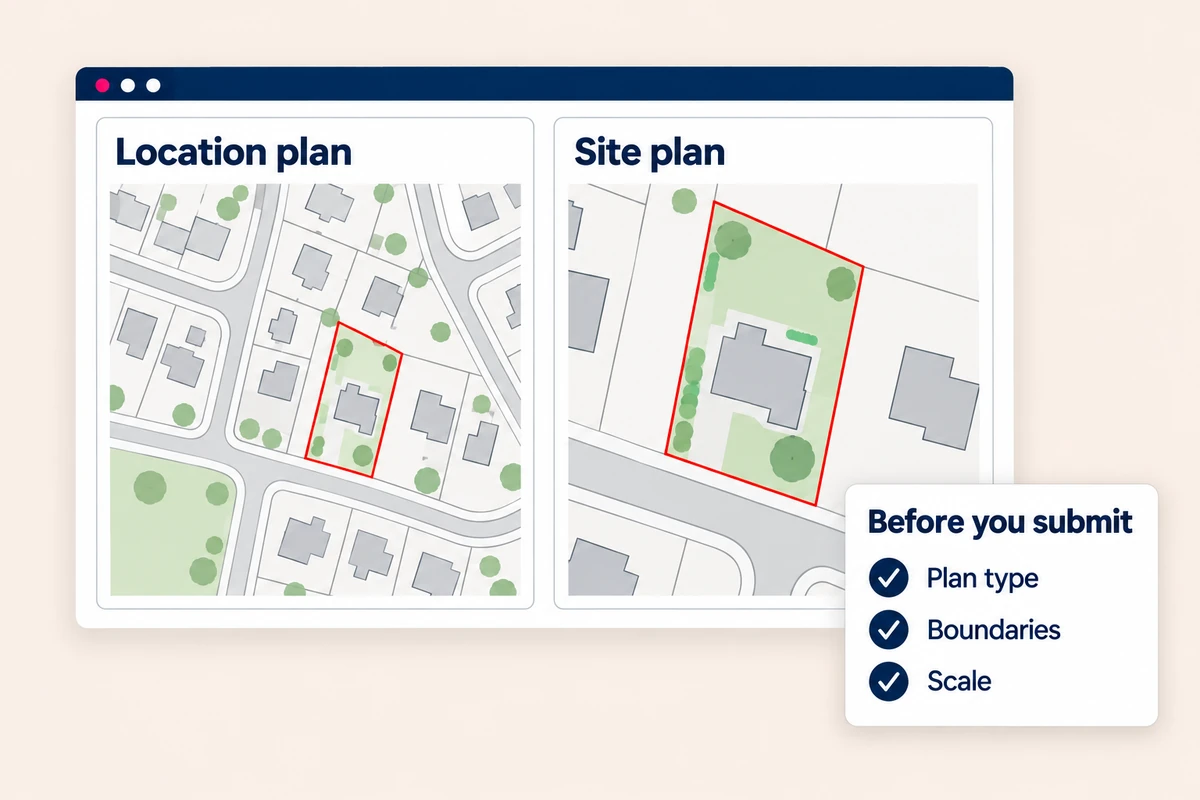
The good news is that these are usually things you can check before submitting. Start with the right location plan and site plan, agree the boundaries, then check the finished files alongside the rest of your application. Here is what to look for.
What planning compliance means for mapping
Planning compliance is a broad subject. Here, we are talking about the maps needed to help get an application validated, rather than whether the proposed development meets planning policy.
Those are different checks. Validation concerns the application information and other submission requirements. The planning decision considers the proposal itself. Buying a suitable map does not guarantee either a complete application or planning permission; it gives you a reliable starting point for the mapping part.
Before ordering, find the checklist for your application type. A householder extension and a change of use may need different supporting drawings, even at the same address. Keep that checklist beside you while preparing the documents.
The national guidance discussed below applies to England. Scotland, Wales and Northern Ireland have their own arrangements, so check the receiving authority's requirements. Our sister website's planning authority directory is a useful place to find your council and follow through to its current guidance.
The difference between a location plan and a site plan
Think of the location plan as the answer to “where is it?” It shows the site within the surrounding area, with enough roads and buildings for someone unfamiliar with the address to find it.
A site plan, also called a block plan, takes a closer look. It helps show the relationship between buildings, gardens, access, parking and neighbouring land. When used as a proposed site plan, it also needs the relevant proposed works drawn onto it.
Our location plans and site plans use licensed Ordnance Survey MasterMap mapping. Choose the product for the job it needs to do, rather than assuming a more detailed map replaces every other drawing.
For example, a rear extension might need a location plan to identify the property, a proposed site plan showing its position in the garden, and separate floor plans and elevations. The base map does not automatically contain the extension design. Agree with your architect or designer who will add that information before you order.
What a council will usually expect to see
For England, national planning application guidance calls for an identified scale and north direction on plans. A linear scale bar is useful, especially for electronic submissions, although it is not itself a national legislative requirement. Check whether your council requires one.
The location plan should be based on an up-to-date map. Its red line should include all land necessary for the development, including any necessary access, parking or landscaping. Blue identifies other land owned by the applicant close to or adjoining the application site, not simply land they use or control.
Ownership and application boundaries are not the same thing. Necessary land belonging to someone else may need to sit inside the red line, with the appropriate ownership certificate and notices addressed. A coloured line does not establish legal ownership or grant access rights.
Keep copyright and licence information visible. Ordnance Survey's planning-map guidance explains that HM Land Registry title plans cannot be reused for planning applications. A title plan may help you discuss ownership, but it is not a substitute for your planning map.
Choosing the right scale for the site
Scale is easier to judge when you look at the whole site, rather than the house alone.
- Location plans commonly use 1:1250 for smaller sites, or 1:2500 where more surrounding area is needed.
- Site and block plans commonly use 1:200 for closer detail, or 1:500 for wider coverage.
At the same paper size, 1:200 shows features larger than 1:500, but covers less ground. If the driveway disappears beyond the page, that closer view may not be the right choice.
For a house on a long plot, check both ends of the site in the preview. For an isolated building, check that the approach road remains recognisable. These quick checks are more useful than choosing a scale purely because it is common for other applications.
If the required scale and coverage will not fit a standard sheet, ask about bespoke maps. Do not shrink a finished plan and leave its original scale label unchanged.
Common mapping mistakes that hold up applications
A frequent source of confusion is treating the red line as a building outline. An extension footprint and an application boundary serve different purposes. If you are unsure about the extent of the application land, agree it with your adviser before drawing the line.
Another avoidable problem is mixing versions. Perhaps the designer has moved the parking space, but the uploaded site plan still shows the earlier layout. Keep one clearly named folder for the final submission, separate from working drafts.
A simple drawing list helps: record each drawing's title, reference, revision and paper size. Check that the filename matches the title on the sheet. Folkestone & Hythe's drawing guidance includes advice on filenames and drawing issue sheets. Your own council may have different instructions, but the underlying habit is useful wherever you apply.
Finally, check the downloaded PDF, not just the editing screen. Look for a clipped boundary, missing label or annotation covering the road. If printing, use the intended paper size at 100% or Actual size and check nothing is cut off. “Fit to page” can change the printed scale.
A practical route from search to submission
Start by finding your property. Enter the postcode, then check you have the right building and plot. No postcode? Use Advanced Search, which offers alternatives including address and coordinates.
Next, choose the plan type and scale from your checklist. Position the map so the relevant land and surrounding context are included, then add the required boundaries. Preview it before completing your order and downloading the PDF.
Pass the base plan to your designer if proposal details need adding. Ask them to return the finished drawing with its scale, paper size and revision clearly identified. If the boundary changes during design work, review all affected plans together rather than replacing just one sheet.
A useful handover message is: “Please confirm whether you need a PDF base plan or an editable CAD file, which scale you want, and who will add the proposed works.” Asking this before buying can save a second order. If an agent is submitting for you, ask them to confirm which final files they have received. An updated drawing in your own folder is no help if an earlier version is still in theirs.
If the council has already queried a map, keep its exact wording handy when asking for help. In a customer review on our website, P Bent described clarifying an order by telephone and getting an answer to a question raised by Shropshire Council before being invoiced. It is a useful reminder that a short conversation can help clear up what is needed.
Check locally, then submit with confidence
Before uploading, put the location plan and site plan side by side. Can you identify the same site on both? Do the boundaries agree? Is it clear which drawing shows the existing situation and which shows the proposal?
Then compare the files against your checklist. Note what each document covers and anything still outstanding. A clear map will not replace a required elevation, survey or supporting report, and a base map cannot replace a measured survey where one is needed.
If a validation request arrives, read what it actually asks for. A request for a corrected plan is not the same as a refusal of planning permission. Confirm what needs changing before ordering another map or asking your designer to redraw it.
Need help choosing the mapping? Call 01856 898 022. Have the site address and the council's request to hand, and we can help you find an appropriate starting point.
Ready to Get Your OS Plans?
Every plan is instantly downloadable, Planning Portal‑compliant, and includes all required elements. Get your plan now and submit your application with confidence.