
PDF Versus CAD Mapping for Planning Applications
Choosing between PDF and CAD mapping is easier when you start with what happens next. Do you need a plan to view, print and include with your application, or mapping your designer can work with? PDF versus CAD mapping is not a choice between basic and better mapping. The same source data can serve different jobs, and some projects use both formats at different stages.
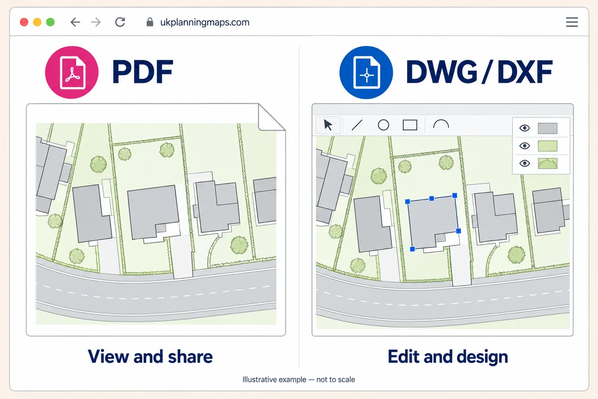
What a PDF planning map is for
A PDF presents the map on a page, with its chosen coverage and layout. You can open it in a suitable browser or PDF reader, email it to your architect and print it without needing CAD software.
That makes PDF planning maps useful for sharing a clear, consistent view of the site. The reader sees the prepared sheet, rather than having to set up drawing layers, a page layout or a print scale themselves.
However, a PDF is not necessarily a flat image. PDFs can contain vector lines, text, images and sometimes layers, and suitable software can annotate or edit them. The distinction is that a PDF is primarily a document for viewing and sharing, not a replacement for the original editable CAD mapping.
Nor does “PDF” mean “complete application”. A location plan may be ready once its details and boundary are checked, while a site plan may still need your proposed development added.
Keep the downloaded PDF rather than replacing it with a screenshot. A screenshot can crop useful information and reduce clarity. If you need to send comments, keep the marked-up review copy separate from the clean document intended for submission.
When a PDF is the right choice
Choose PDF when the next task is to inspect, share, print or upload the finished plan. It is often the straightforward option for a homeowner who needs a location plan and has no reason to alter the underlying mapping.
For example, your designer might already be preparing the proposed site layout but ask you to supply the location plan. You may only need the appropriate PDF, not a second editable drawing file.
Before ordering, agree who is providing each plan. Check the council’s requirements and what your chosen application service already supplies. This avoids buying something twice or assuming your architect has included mapping that is outside their fee.
If the request is simply “send me the map”, ask one more question: “Do you need a PDF to view, or DWG or DXF to edit?” That small clarification can save another order.
What CAD mapping is for
CAD mapping supplies editable drawing data, usually as DWG or DXF files. Architects, designers and other professionals use it as a base for preparing site layouts and coordinating their own drawings.
UK Planning Maps’ CAD maps are layered and georeferenced. Their coordinates position the mapping in its geographic location. Georeferencing is about position; it does not mean every feature has been surveyed specifically for your project.
Keep an untouched copy of the supplied file. Before moving, rotating or rescaling the working drawing, agree the coordinate approach with your designer. A drawing moved close to a convenient local origin may no longer line up directly with other georeferenced information.
Confirm the software, supported file version and drawing units too. DWG and DXF are common exchange choices, but they are not a promise that every program will handle every file identically.
Layer control helps the designer distinguish the supplied base from new work. For instance, an extension outline and its notes can sit on separate layers from the existing map features. That makes revisions easier to follow without altering the original mapping.
CAD is useful where there is genuine drawing work to do. You do not need to learn it simply because your project is a planning application.
PDF versus CAD mapping: the practical differences
The useful comparison is between tasks, rather than which format sounds more professional.
| Your next task | CAD: DWG or DXF | |
|---|---|---|
| View and share a prepared plan | Usually the simpler choice | Needs suitable viewing software |
| Edit the mapping in a drawing | Possible limitations and conversion work | The more useful starting file |
| Prepare a submission sheet | Check the finished document | Set up the sheet, then export as required |
CAD does not make the source mapping inherently more accurate or more up to date. Its advantage is access to usable drawing geometry and structure.
Converting a PDF to CAD is not always a clean shortcut. Some geometry may import, but text, curves, layers and precision can change. An image-only PDF does not contain editable vector linework to recover. Autodesk explains the limitations of importing PDF files. If your designer needs CAD, ordering it at the start is usually easier than rebuilding a PDF.
The reverse workflow is perfectly normal: work in CAD, then export a PDF for checking and submission. You are choosing the right file for each stage, not committing the whole project to one format.
Planning compliance is about more than file type
A file extension does not establish whether a plan meets the receiving authority’s requirements. The finished drawing must provide the right information for the application, at a readable scale, with appropriate coverage and licensing.
Check the relevant guidance for your UK nation and council. Typical location plan scales are 1:1250 or 1:2500; detailed site plans commonly use 1:200 or 1:500. The site and the authority’s instructions should determine the choice.
Keep the supplied copyright and licence information visible. Check the north point, application boundary and surrounding context, and make sure any required proposal detail has been added. Purchasing a base map does not draw an extension, establish ownership or replace a measured survey where one is needed.
Do not assume an upload system accepts DWG simply because your designer uses it. Check the permitted submission formats, document size limits and any naming instructions before preparing the final files.
For a practical final check, use the planning map checklist on our sister website, Planning Maps UK. Work through it with the actual file you intend to send, alongside your council’s own checklist.
Choosing the right file before you order
Send your designer a short brief: “Please confirm the format and version, the area required, and who will prepare the final submission PDFs.” Include relevant access and neighbouring context when agreeing coverage, rather than selecting only the building.
For CAD, separate drawing units from printed scale. The model is normally drawn at full size, or 1:1, using agreed units. A sheet or viewport then presents it at a scale such as 1:500. Importing the base at a fraction of its size is not the way to create that printed scale.
Check a known length after import. If metres have been interpreted as millimetres, resolve the unit settings before continuing; do not resize the map until it merely looks right.
Before issuing a PDF, open the exported file outside the drawing program. Check for missing references, substituted fonts, clipped labels and boundary lines that become too heavy or faint. View the whole sheet, then inspect the detail.
If printing to scale, select the intended paper size and use “Actual size” or 100%, checking that nothing is cropped. “Fit to page” can change the scale. Adobe’s page-size guidance explains these settings.
A useful handover includes the drawing reference, revision and intended paper size. If a consultant is receiving CAD, also tell them which coordinate approach and units were used. These details remove guesswork when somebody else opens the file a week later.
Help is available if you get stuck with the tools. In her customer review, Rachelle Lewis described misunderstanding the software and being talked through it by phone until the problem was resolved. She wrote: “I phoned for help and my call was answered straight away.” Contact us if you need a hand, rather than struggling on alone.
A straightforward rule for applicants and professionals
Use PDF when you need a prepared document to view, share or submit after checking. Use CAD when someone needs to work with editable, georeferenced mapping in their design software. Use both when the job starts with drawing work and finishes with a PDF submission.
Keep the original mapping, working drawing and final issued PDF separately, with clear filenames. If changes are requested, everyone should know which file is the source and which version was submitted.
Ready to start? Find your planning map, or call 01856 898 022 if you need help with the mapping options.
Ready to Get Your OS Plans?
Every plan is instantly downloadable, Planning Portal‑compliant, and includes all required elements. Get your plan now and submit your application with confidence.