
Map Scales for UK Planning Applications Explained
If you have been asked for a planning map, the choice of scales can be confusing. Do you need 1:1250 or 1:2500? Is a 1:500 site plan enough, or should it be 1:200? The answer depends on what the drawing needs to show. Some plans help the council find your property. Others show what you want to build and how it fits on the site.
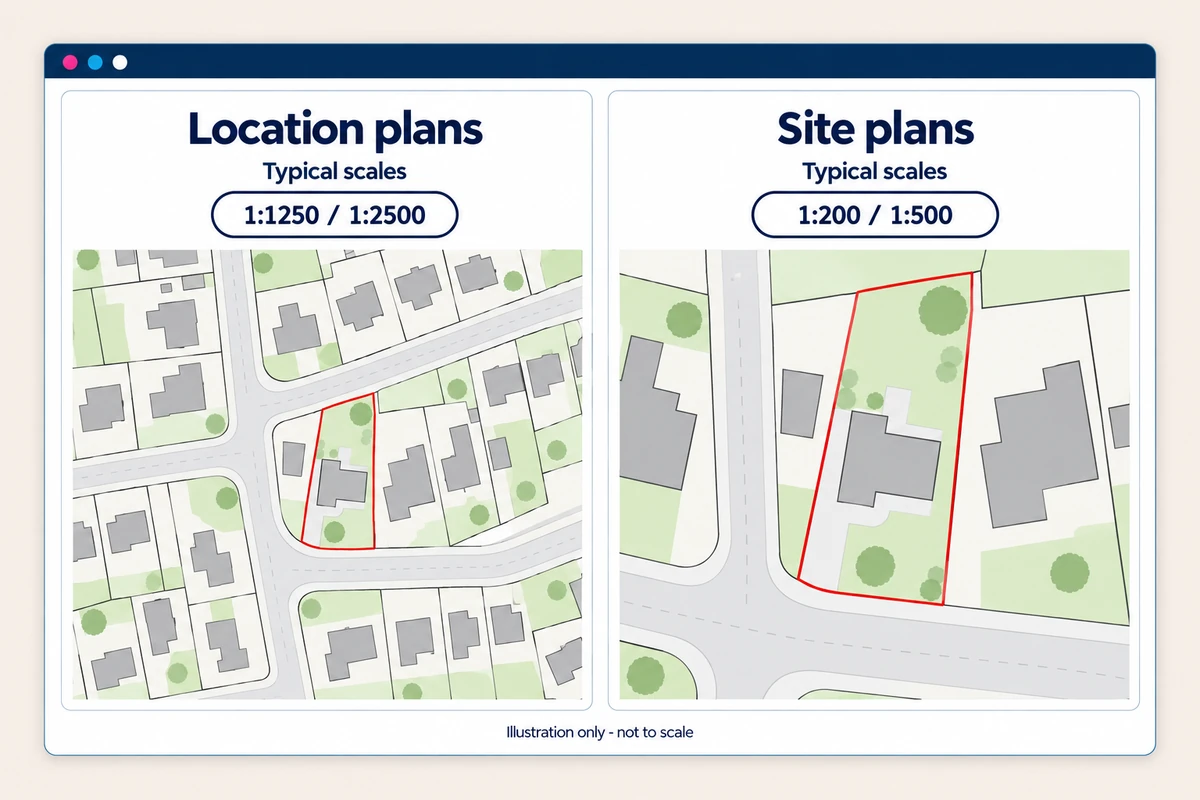
You do not need to become a map expert to choose between them. Start with the council's requirements, then check that the plan includes the right area at a readable size. Here is how the main map scales work and when each is useful.
What do map scales mean?
A map scale tells you how a distance on the page relates to a distance on the ground. At 1:500, one centimetre on the correctly sized plan represents five metres in real life.
The numbers can feel back to front at first. A 1:200 plan shows things larger than a 1:500 plan, while 1:2500 gives a wider view than 1:1250. That comparison assumes the same size map area on the page.
For a quick reference, one centimetre represents:
- 2 metres at 1:200
- 5 metres at 1:500
- 12.5 metres at 1:1250
- 25 metres at 1:2500
That is why a location plan and a site plan do different jobs. One provides the wider setting; the other brings the plot into closer view. Neither is automatically better. They simply answer different questions.
The planning map scales you will use most often
These four scales are common starting points for planning maps. They are not a promise that every council will accept the same drawing set. Check the requirements for your application type and UK nation before buying.
1:1250 for most location plans
A 1:1250 location plan is often a good starting point for a house in a town, village or built-up area. It can show the property alongside neighbouring buildings and roads without making everything too small.
For a typical householder application, the useful question is: could someone who has never visited find the site from this plan? You know which house is yours, but the planning officer needs enough surrounding information to identify it too.
Check the edges of the preview. The whole application site should fit comfortably, with recognisable surroundings. If a necessary access track disappears off the page, a different coverage or scale may be needed.
1:2500 for larger or rural locations
A 1:2500 location plan gives you more room to show the setting. It can be useful for a farm, an isolated property or land reached by a long access track.
At the same map-window size, it shows twice the ground distance in each direction compared with 1:1250. The trade-off is that buildings and boundaries appear smaller.
For a barn conversion, this wider view might help connect the site to a nearby road. You may then need a separate site plan to show the barn, parking and proposed works. Showing the location clearly and explaining the layout are still two separate tasks.
1:500 for site and block plans
A 1:500 site plan, also called a block plan, brings the site into closer view. It is commonly used to show buildings, gardens, access and nearby properties in relation to one another.
For an extension, this is where the position of the proposed work becomes important. The council may need to see its relationship to the house, boundaries and neighbouring buildings, along with relevant parking, trees or access arrangements.
There is an important distinction here: the base map and the proposed site plan are not necessarily the same finished document. Your proposed extension will not already be on the mapping. Agree who will add the design, dimensions and other required details, whether that is you, your architect or your designer.
1:200 for close site detail
A 1:200 plan gives more space on the page to show a compact plot or a detailed arrangement. Parking spaces, a small garden layout or a building close to a boundary may be easier to explain at this scale.
It also covers less ground, so check that the relevant site still fits. A close view is not much help if it cuts off the access you need to show.
Remember that a larger-scale print does not make the underlying mapping more accurate. If the design depends on precise distances to a wall or building, those measurements may need checking on site. Enlarging the map is not a substitute for a measured survey.
How to choose the right scale for your application
Start with the council's validation checklist. If it specifies a scale, work to that requirement rather than choosing by appearance alone.
Next, look at the shape of the site. A small house with a very long driveway may need more coverage than a larger building on a compact plot. The postcode will find the area, but it cannot tell you how much land your application needs to include.
A householder application might use a 1:1250 location plan alongside a 1:500 block plan. A rural project might use 1:2500 for the location and a closer plan for the proposed works. These are examples, not fixed combinations.
If the required scale will not show enough land on the standard sheet, ask about bespoke map coverage or a larger paper size. Do not simply squeeze the map into a smaller space and keep the old scale label.
What makes a planning map acceptable?
Scale matters, but it is only part of the check. The plan also needs to be legible, appropriately licensed and suitable for the information the council has requested.
In England, national planning guidance requires an identified scale and north direction on plans. A scale bar is useful for electronic submissions, although it is not itself a national legislative requirement. Your council may require one.
The guidance also calls for an up-to-date location map, a red outline around all land necessary for the development, and blue around other applicant-owned land nearby or adjoining the site. Blue does not mean any land you happen to use or control.
Check the finished PDF at its intended paper size. When printing, select Actual size or 100% and make sure nothing is clipped. A scale bar resized uniformly with the map still helps interpret distances, but it does not keep the printed numerical scale correct. Avoid “Fit to page” when you need a print at the stated scale.
Common mistakes that cause avoidable problems
One mistake is expecting a single plan to do everything. A close-up drawing may explain an extension perfectly while leaving its location unclear. A wider map may locate the property but make the proposed layout difficult to read.
Another is choosing coverage before agreeing the application boundary. Check the relevant access and other necessary land first; otherwise, you may discover that the map you bought stops short of what you need.
Screenshots can cause problems too. Copying a view from a mapping website does not necessarily give you a suitable scale, licence or readable submission file. Use mapping intended for the purpose and keep its copyright and licence information visible.
Finally, do not judge a PDF's scale by how large it looks on your monitor. Changing the viewer's zoom does not change the document's defined scale at its intended print size.
Create the plan at the scale you need
Use our sister website's planning authority directory to find your council, then follow through to its current guidance.
When you know what is needed, find your property, choose the plan type and scale, and check the coverage. No postcode? Advanced Search offers other ways to find the site.
UK Planning Maps supplies licensed Ordnance Survey MasterMap-based plans at 1:200, 1:500, 1:1250 and 1:2500, with immediate PDF downloads after ordering. Preview the map and check any boundaries you have added before paying.
If you are still unsure which option fits, call 01856 898 022 with the site details and the council's request. We can help you choose the mapping, while your adviser can confirm any proposal drawings needed alongside it.
Ready to Get Your OS Plans?
Every plan is instantly downloadable, Planning Portal‑compliant, and includes all required elements. Get your plan now and submit your application with confidence.