
Map Boundary Requirements for Planning Plans
A planning application can be delayed for a surprisingly small reason: the red line on the map does not cover all of the land needed for the proposal. Map boundary requirements are not just a drawing convention. They help the local planning authority understand exactly where development is proposed, who may be affected, and whether the correct notices and ownership declarations have been made.
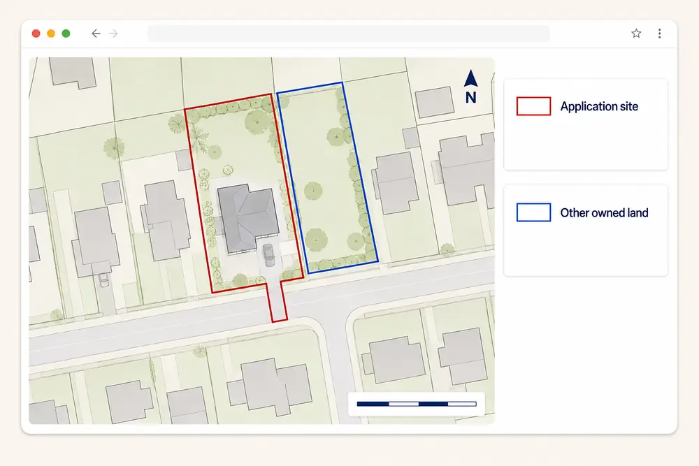
A planning map can still come back with a request for changes because the boundary is in the wrong place. It may be a small line, but it tells the planning authority exactly which land the application relates to.
Most boundary questions concern the location plan rather than the detailed site or block plan. The location plan identifies the site in its wider setting, usually with a red line. A blue line may also be needed for other nearby land owned by the applicant. Getting both right can prevent a validation query.
What map boundary requirements mean
The red boundary defines the application site. It should form a clear, unbroken shape around all land covered by the proposal. That is often more than the footprint of a new extension, garage or building. It may include the existing property, garden, driveway, parking and access to the public highway.
These formal red and blue boundary conventions primarily belong on the location plan. Some authorities ask for a matching boundary on the block or site plan, but this is not universal. Repeat it only when the local validation checklist asks. If both plans show a boundary, they should describe the same site.
A planning map does not settle a legal boundary or prove ownership. Ordnance Survey mapping records features on the ground; it is not a substitute for title documents or professional advice. The line explains the application area. If ownership is uncertain or disputed, check the Land Registry documents and seek appropriate advice.
For a clearer comparison of the plans themselves, see Location Plan vs Site Plan: What Planning Needs.
Draw the red boundary around all relevant land
Start by asking: what land is genuinely part of this application? Trace its outside edge and close the line without gaps. A red box around the proposed work alone is a common mistake. For a house extension, the site will usually include the house and relevant residential plot, not just the extension footprint.
Look at how the site is reached. A driveway or track that is relevant to the application will normally need to sit inside the red line. This is easily missed with backland plots, rural sites and long private drives. Stopping at the gate or parking space can leave the site cut off from the highway.
Keep the line close to the site boundary, but not so heavy that it hides buildings, paths or roads. Use enough points to follow corners, then check that the final point joins the first. The outline should remain obvious when the whole page is viewed.
The practical steps and examples in How to Draw a Red Line Boundary for Planning are useful if you are unsure where to begin.
Shared access and land you do not own
Shared access needs more thought. Land can sometimes be included within the application boundary even if the applicant does not own every part, provided it is relevant to the proposal. Ownership certificates and notices address ownership; the coloured line shows the application site. Do not alter the red line merely to avoid showing somebody else's interest.
Do not include a neighbour's garden or unrelated road for convenience. Show the land needed to describe the proposal and access accurately. If a route is shared, leased or owned by someone else, check which ownership certificate applies and whether notice must be served. Ask the authority or your planning adviser about unusual arrangements.
When to use a blue boundary
A blue line is conditional; not every location plan needs one. If the applicant owns other land close to or adjoining the application site, that land is normally outlined in blue. It sits outside the red line and is not part of the application site.
An applicant might own the house and garden inside the red line plus a neighbouring field outside the development. The nearby field can be outlined separately in blue. Do not outline somebody else's land in blue or colour the same land red and blue.
Do not add blue merely because the tool is available. Check whether the applicant owns other close or adjoining land and read the current local guidance. Our Blue Line Planning Application Boundary Explained guide covers the distinction.
Scale, coverage, and plan quality still matter
An accurate boundary will not rescue a plan at the wrong scale or with too little surrounding detail. A location plan is typically 1:1250 or 1:2500, although another suitable scale may be accepted. A site or block plan is commonly 1:200 or 1:500. Use the scale requested locally and show enough named roads, buildings or recognisable features to find the site, together with a north point and scale information. A linear scale bar is useful for electronic plans and may be required by the authority.
The whole red boundary must fit within the map area. If the site or access disappears off the edge, choose broader coverage rather than stretching the PDF. Do not resize a scale plan to make it fit. When printing, use the original paper size and “actual size” or 100% unless instructed otherwise.
Use current, licensed mapping rather than an online-map screenshot. UK Planning Maps supplies plans using current Ordnance Survey MasterMap data and covers Great Britain — England, Scotland and Wales — but not Northern Ireland. The PDF is available for immediate website download after ordering. The email copy can occasionally take up to 20 minutes, so use the website download if it is urgent.
Inspect the preview at normal size. Check that the line is easy to follow, the property is identifiable and important mapping remains visible. A crisp PDF is easier to assess than a blurred screenshot or scanned printout.
Common boundary mistakes that delay applications
Most problems are small and avoidable. A quick final check should catch these common issues:
- Drawing around the proposed building work instead of the complete application site
- Leaving out a driveway, track or other necessary access to the public highway
- Leaving a gap in the red line or allowing the outline to run off the page
- Including unrelated neighbouring land inside the application boundary
- Adding a blue line when there is no other relevant land in the applicant's ownership
- Drawing lines so thickly that they hide buildings, boundaries or road names
- Showing different site extents on the location plan and block or site plan
- Using out-of-date, unlicensed or poor-quality mapping
Compare the plan with the application form, address and drawings. If the form describes one parcel but the map encloses another, the council may need clarification. The same applies when a drawn access sits outside the location-plan boundary.
One review shows why the final preview matters. In Mr Wellden's review, he said the red outline was missing from his first map and that UK Planning Maps resolved the issue through online chat. That was one customer's experience, not a guarantee of validation or planning approval.
A request for a corrected plan is normally a validation matter: the authority needs suitable information before processing the application. It does not say whether permission will be approved or refused. Correcting the boundary helps the application move forward but cannot guarantee the decision.
Check the local authority before you submit
National conventions are a useful starting point, but councils publish their own validation checklists. Read the relevant list, especially for a large or rural site, several parcels or shared access. Check whether the authority wants the red line repeated on the block plan, expects blue, or specifies a paper size or scale.
Before paying, confirm that the right property is centred, the whole red outline is visible and any necessary blue outline is separate. Make sure the scale, north point and surrounding roads can be read. Then compare the downloaded PDF with the rest of the submission.
If the authority asks for a change, follow its exact wording. It may want missing access, a revised site area, a blue ownership boundary or a clearer plan. Changing colour or thickness will not correct the wrong area. If unclear, ask the validation team before redrawing.
Clear map boundaries do not make the planning case for a development, but they do remove uncertainty about where the proposal sits. Draw the red line around the full application site, use blue only where it applies, and check the plan against the local list. Those few steps can prevent a straightforward mapping query from holding up the submission.
Ready to Get Your OS Plans?
Every plan is instantly downloadable, Planning Portal‑compliant, and includes all required elements. Get your plan now and submit your application with confidence.