
How to Order a Block Plan for a Planning Application
If your council has asked for a block plan, the first job is to work out what needs to fit on it. The house alone may not be enough: the garden, access and nearby buildings can matter too. This guide explains how to order block plans, choose a suitable scale and check the preview, so you buy the mapping you actually need. it relates to nearby buildings, boundaries, roads and land.
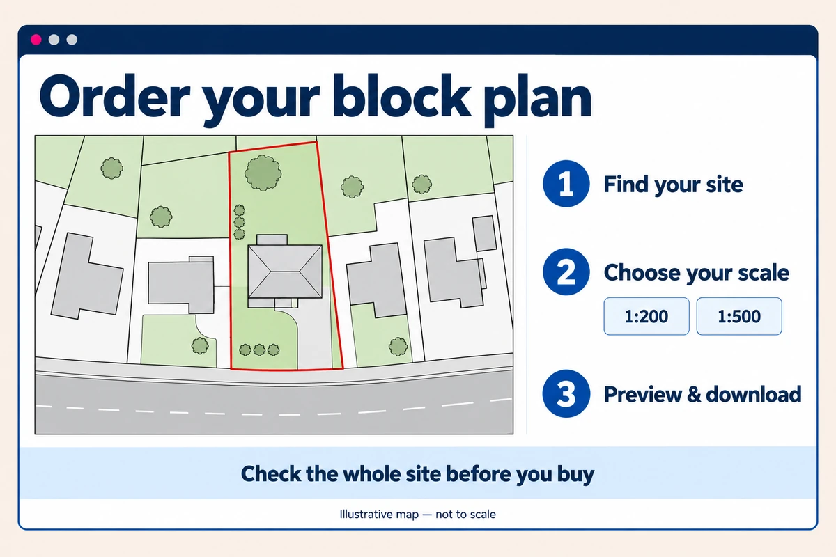
What is a block plan?
A block plan, also called a site plan, gives a close-up view of a property and its immediate surroundings. For a planning application, the finished drawing helps explain where the proposed work sits within the site.
The Planning Portal describes site and block plans as typically being prepared at 1:200 or 1:500. At 1:200, features appear larger on the page. At 1:500, the same-sized map frame covers more ground. Neither is automatically the right choice for every property.
There is an important distinction when ordering. The map gives you the existing external setting; it does not automatically include your new extension, parking layout or landscaping. You or your designer may need to add those details to make the proposed block plan.
Check your planning authority's requirements first. The detailed national rules mentioned here apply to England; other UK nations and different application types have their own requirements.
Block plan, location plan or both?
A location plan shows where the site is in the wider area. A block plan moves closer in and shows the arrangement within and immediately around it. Many applications need both.
Our location plans are available at 1:1250 and 1:2500. They help identify the property among surrounding roads and buildings. A block plan then gives the closer view needed to explain the layout.
For an extension, think of the location plan as answering “Which property?” and the proposed block plan as answering “Where will the extension go?” Floor plans and elevations explain other aspects of the design.
Do not order the most detailed map and assume it covers every requirement. Read the document list your council or designer has given you, and check whether a location plan is needed as well.
What to prepare before you order block plans
Have the address or postcode ready, along with any drawing or instructions your designer has supplied. For a field, rear garden plot or property without a postal address, use Advanced Search. Check the position carefully rather than relying on the nearest postcode.
It also helps to agree these points before opening the drawing tools:
- Which land forms the application site?
- Is any necessary access outside the main plot?
- What scale and paper size have been requested?
- Who will add the proposed development?
- Does that person want PDF or CAD mapping?
In England, the national location-plan guidance says the red line should include all land necessary for the development, including necessary access from a public highway. Other relevant areas can include parking, landscaping and visibility splays. Other applicant-owned land close to or adjoining the site should be edged blue.
These lines need thought where land or access is shared. Ask your adviser about the application boundary, ownership certificates and any notices required. A line on a planning map does not create ownership or a right of access.
You can find your council's planning guidance through our sister website, then follow through to the council's current validation checklist.
How to order block plans online
1. Find the correct property
Start on our site-plan page and search for the property. Check the building, adjoining road and neighbouring plots before moving on. This is particularly useful where several buildings share an address or a lane has similarly named houses.
2. Choose the scale and coverage
Our standard A4 1:200 plan covers 36 metres by 36 metres. The standard A4 1:500 option covers 90 metres by 90 metres. Compare the current sizes, samples and prices, rather than choosing by price alone.
For example, a small house might fit at 1:200 while its long garden does not. Try the complete site in the preview. If a specified scale will not cover everything, ask about a larger sheet or bespoke coverage instead of cutting off part of the land. Choose the file format agreed with whoever is preparing your drawings.
3. Position the map
Move the view until the relevant site and enough surrounding detail are visible. Leave a little room around the boundary. The house need not sit precisely in the centre if that would push the entrance or a detached garage out of the frame.
4. Add the boundary
Use the drawing tools to mark the agreed application site and any relevant blue boundary. Keep lines clear without covering important detail. Our site plans already include a north arrow, scale bar and OS licence information, so you do not need to add those yourself.
5. Check the preview before paying
Take a final look at these points:
- Is it definitely the correct property?
- Does the whole relevant site fit, including necessary access?
- Are the scale and paper size right?
- Are the boundaries clear and consistent with your other drawings?
- Can someone unfamiliar with the site understand the view?
Check what the map shows now against the instructions for the finished drawing. If the proposed development still needs adding, agree who will do that before treating the plan as ready to submit.
6. Complete the order and save the file
After purchase, download your file immediately and keep it in your project folder. Open it to check the document itself, not just the preview. Printed copies are also available; check the current options and charges when ordering.
Details your block plan may need to show
The finished plan should explain the proposal clearly. Depending on the application, that may mean showing existing and proposed buildings, their relationship to boundaries, access, parking, adjoining roads and relevant trees or other features.
Imagine a detached garage behind a house. A map showing the house and garden is the starting point. The proposed drawing may also need the garage's position, dimensions and access arrangements. Simply writing “garage” in an empty corner does not explain its size or relationship to neighbouring land.
For a more involved scheme, ask your designer about drainage, landscaping, cycle parking, bin storage or visibility details. Keep labels readable and use a clear key where needed. Distinguish what exists from what is proposed, rather than leaving the reader to work it out.
Our mapping is not a measured survey of every feature. If something important is missing or has changed, raise it with the person preparing the drawings.
Common ordering mistakes and how to avoid them
A tight crop is easy to choose and sometimes difficult to use. Before paying, look for the bits that tend to disappear: the far end of a garden, a turning area or the entrance from the road.
Choosing 1:200 because it sounds more detailed can also be misleading. Enlarging the mapping makes features easier to see; it does not improve the accuracy of the underlying survey or add missing information.
Keep the same agreed site extent across the application drawings, and make sure the ownership paperwork relates to that same application land. Ask your adviser if the documents seem to describe different areas.
When printing a scaled PDF, use actual size or 100% on the intended paper. Avoid “fit to page”, which can shrink it. Keep copyright information visible and do not substitute a screenshot for the purchased file.
If the drawing tools are giving you trouble, ask us. In our site-plan reviews, one customer reported that Rachel had sorted out a red-line problem within an hour. A quick conversation about the difficulty can be more useful than repeatedly trying the same thing.
When you may need more than a standard PDF
Our PDFs are not georeferenced. If your architect needs editable, georeferenced mapping, ask whether our DWG or DXF files suit their workflow. Check before buying: not every homeowner needs CAD.
For an unusually shaped site or different coverage, our bespoke mapping service may be more suitable. Explain what needs to fit and any scale your adviser has specified.
Ready to order? Start with the site-plan preview, or call 01856 898 022 if you need help choosing the mapping. Check the finished drawing against your council's requirements before submitting; buying a suitable map is one part of preparing the application, not a guarantee of validation or planning permission.
Ready to Get Your OS Plans?
Every plan is instantly downloadable, Planning Portal‑compliant, and includes all required elements. Get your plan now and submit your application with confidence.