
CAD Mapping Files for UK Planning Projects
A proposed extension can be perfectly designed and still lose time if the base drawing is wrong. CAD mapping files give architects, homeowners, surveyors and planning professionals an accurate digital starting point for site layouts, access plans, drainage concepts and proposed works. The key is choosing mapping that suits the job, uses the right scale and remains properly licensed for the drawings you need to submit or share.
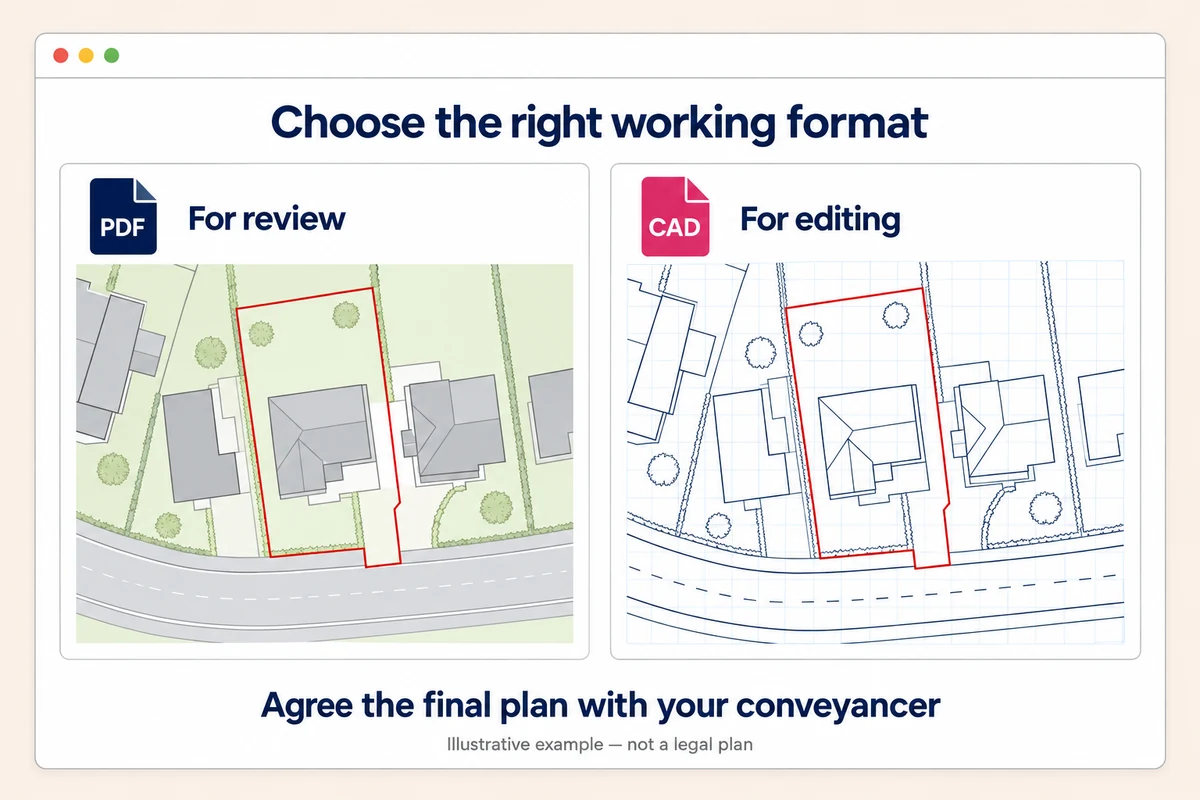
Unlike a flat image or scanned plan, a CAD file contains editable mapping data. Buildings, roads, boundaries and other mapped features can be placed into design software, combined with survey information and used as the background for a drawing. That saves redrawing time, reduces the chance of copying features inaccurately and helps keep proposals aligned with the real-world site.
What are CAD mapping files used for?
CAD mapping files are digital map extracts supplied in a format that can be opened and edited in computer-aided design software. They are widely used before a planning application is ready for submission, particularly where a designer needs to show a proposed extension, new dwelling, parking layout, access route or development boundary accurately against existing surroundings.
For a homeowner, the practical benefit may be simple: their architect can begin with a reliable map rather than tracing a PDF. For a developer or planning consultant, the benefit is repeatability. The same mapped base can support an existing site plan, a proposed block plan, a landscaping layout and other technical drawings, provided the licence and mapping extent are appropriate.
CAD mapping should not be confused with a finished planning location plan. A planning authority will usually expect a clear, correctly scaled document - commonly a PDF - with the site boundary marked in red and any adjoining or related land shown in blue where applicable. The CAD file is often the working source; the final plan is the drawing exported for the application. Some projects need both.
Choosing the right CAD map format
The best format depends on the software in use and the person receiving the file. DWG is a common choice for AutoCAD-based workflows, while DXF is often preferred when a file needs to move between different CAD packages. Before ordering, check what the architect, technician or surveyor actually requires. Asking for a format after the drawing work has begun can create unnecessary conversion work.
It is also worth confirming whether the supplied file is vector mapping rather than a simple image inserted into a CAD drawing. Vector data is made up of editable lines, points and polygons. It can be selected, placed on layers and used alongside design information. A raster image may look acceptable on screen, but it does not offer the same control and can become unclear when enlarged.
Coordinate reference and units matter on larger or more technical schemes. If a CAD map must align with topographical survey data, drainage designs or engineering drawings, the project team should agree its coordinate system at the outset. Mixing local drawing coordinates with nationally referenced data can leave plans offset, rotated or at an incorrect size. This is usually easy to prevent, but awkward to correct once several consultants have added work.
Scale: match the map to the decision being made
Scale determines how much context appears around the site and how much detail can be shown clearly. There is no single best scale for every project.
A 1:2500 location plan is normally used to identify a site within its wider setting. It gives planning officers enough surrounding context to understand where the land or property sits. A 1:1250 plan is commonly suitable for urban and suburban locations, where plots are close together and a smaller area provides the necessary context.
For the site itself, 1:500 is often a practical starting point. It can show the building, garden, access, neighbouring land and proposed works without becoming crowded. A 1:200 plan is more detailed and may be useful where a compact site, intricate layout or close relationship with neighbouring features needs to be understood.
The scale required can vary by local planning authority and by the nature of the application. Read the authority's validation requirements before finalising the drawing. A map that is accurate but too tightly cropped, too small to read or at an unsuitable scale may still result in a validation query.
Why licensed mapping matters
Base mapping is intellectual property, not unrestricted public data. Ordnance Survey mapping is supplied under licence, and that licence governs how it can be used, reproduced and shared. Using a screenshot from an online map, an old plan of uncertain origin or copied mapping from another consultant can create both quality and permission problems.
Licensed Ordnance Survey MasterMap-based mapping provides a dependable base for professional work. It is detailed, current enough for its intended mapping purpose and formatted to be used in recognised planning and design workflows. It also gives the purchaser a clear route to obtain mapping legitimately, rather than relying on a source that may not be suitable for formal documents.
Licensing is especially relevant when CAD files are passed between a homeowner, architect, planning consultant and contractor. A file bought for a particular project can usually support that project, but it should not automatically be treated as a general asset for unrelated schemes or wider distribution. If several parties need to use the data, clarify the intended use when ordering.
Preparing a CAD base for planning drawings
A good CAD file saves time only if it is set up carefully. Start by checking that the mapped area covers the full site and enough of the neighbouring context to explain the proposal. A rear extension may need the whole garden and adjacent properties visible; a new access may require the adjoining road, junction and verge.
Next, keep the mapping base separate from proposed work. Existing mapping should remain identifiable, while additions such as proposed buildings, demolition lines, parking bays, planting and annotations should sit on their own layers. This makes revisions safer and helps produce a clear final PDF.
Before plotting, check four practical points:
- The drawing scale prints correctly on the intended paper size.
- The north point and scale bar are visible where required.
- Boundary markings remain clear when printed or viewed as a PDF.
- Text, dimensions and proposal lines do not obscure key mapped features.
These checks sound basic, but they prevent common issues. A red boundary line that appears obvious in CAD can disappear against another red annotation, or become too fine after export. Likewise, a plan may show the right area on screen but lose its stated scale when printed using an incorrect page setting.
When a PDF plan may be the better choice
Not every applicant needs an editable file. If the only requirement is a location plan or site plan for a straightforward householder application, a ready-made PDF is often quicker and more economical. It can be created at the correct planning scale, marked with boundaries and downloaded immediately.
CAD becomes more worthwhile when someone needs to add detailed proposals, coordinate information with other drawings or produce several related plans from one base. It is particularly useful for architects, builders preparing layouts, surveyors and consultants managing repeated projects. The choice is not about one product being better than the other; it is about avoiding unnecessary complexity for a simple submission while retaining flexibility where a design workflow demands it.
UK Planning Maps supplies professionally licensed mapping at standard planning scales, with digital options for users who need an accurate working base as well as application-ready plans. Search can be carried out by postcode, address, coordinates or directly on a map, which is useful where a plot has no straightforward postal address.
A faster way to avoid drawing delays
Order the mapping before design work reaches the deadline stage. Give the person preparing the CAD drawing the correct site extent, required scale and file format from the start, then retain the original downloaded file with the project records. If the application changes, the team can work from a known, licensed base instead of rebuilding the drawing under pressure.
For first-time applicants, the most useful question is often not “Which CAD file do I need?” but “Who will use it, and what must the final plan show?” Once that is clear, the format and scale usually follow. A well-chosen map is quiet background work, but it gives every later drawing a firmer footing.
Ready to Get Your OS Plans?
Every plan is instantly downloadable, Planning Portal‑compliant, and includes all required elements. Get your plan now and submit your application with confidence.