
Barn Conversion Mapping for Planning Applications
A barn conversion is rarely just about the building. There may be a long track, a shared yard, a field you hope to use as a garden and nowhere obvious to put the cars. Good barn conversion mapping helps you explain how those pieces fit together, so the council can understand the proposal without having to guess.
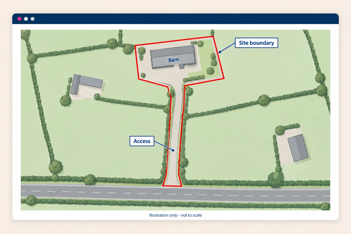
Getting the maps ready early also helps you spot gaps in your plans. Does the proposed garden sit inside the application boundary? Is the entrance shown? Have you allowed for drainage? These are easier questions to settle before your architect finishes the drawings than after the application has gone in.
Why mapping matters for a barn conversion
You may know every gate and outbuilding on the farm. The person reviewing your application probably will not. Your maps need to identify the right barn and show its relationship to neighbouring homes, working farm buildings, roads and surrounding land.
Start by checking the building itself. Several barns can share one postcode, and the search marker may land on the farmhouse. Compare the map with the site, rather than assuming the first building you see is yours. If necessary, agree a clear building label with your designer and use it throughout the application.
Next, check which application route you are using. Full planning applications and prior-approval applications do not have identical requirements. Our sister website's planning-permission guide is a useful starting point, but it cannot confirm whether your particular barn qualifies. Your council's current checklist and your planning adviser's advice should guide the drawing pack.
The two plans most applications need
A location plan and a site or block plan do different jobs. One helps the reader find the site; the other explains what happens within it. Neither replaces the architectural drawings of the conversion.
Location plan: showing the site in context
A location plan commonly uses a scale of 1:1250 or 1:2500. The latter often gives rural sites more room, particularly where the barn is some distance from the public road. Choose coverage that shows the complete application site and enough surrounding detail to identify it.
Do not centre the map tightly on the roof and cut off the approach. A long access track may be more important to understanding the proposal than an extra field behind the barn. If the necessary coverage will not fit at the required scale, ask about a suitable paper size or bespoke plan.
Site or block plan: showing the practical detail
A site or block plan is commonly prepared at 1:500 or, for a closer view, 1:200. Your council may request a particular scale. The proposed drawing should make the everyday layout clear, including relevant details such as:
- The barn and any buildings being retained or removed
- Vehicle access, parking and turning space
- Garden areas, gates, walls and fences
- Bin storage and collection arrangements
- Proposed drainage equipment and associated land
- Nearby buildings or features affected by the conversion
Buying the base mapping does not automatically add your proposed layout. Agree who will draw those details: you, your architect or another suitably qualified designer. A measured survey may also be needed where accurate dimensions or levels matter.
Getting the red line right
The red line defines the application site, not simply the outline of the barn or everything you own. For full planning applications in England, national guidance says it should cover all land necessary for the development, including access from a public highway and relevant parking, gardens and other supporting land.
An existing track is not automatically left out just because you are not resurfacing it. Equally, a distant stretch of public road does not become part of your site merely because visitors drive along it. With a long or shared farm track, agree the appropriate application extent with your planning adviser before ordering.
Ownership is a separate question. Necessary land can belong to someone else; for a full planning application, the appropriate ownership certificate and notices must be considered. A blue line identifies other nearby or adjoining land owned by the applicant, not any land they happen to use. Procedures differ between application routes, so check yours.
Planning permission does not grant a private right to cross a neighbour's land. Ask your solicitor to check the access rights separately. Drawing a track in red does not settle who owns it or who may use it.
Avoid drawing an unnecessarily generous garden around a barn without discussing the intended use. Including agricultural land inside a red line does not, by itself, make residential use acceptable or authorised.
Rural details that are easy to miss
Walk the site with your proposed layout in mind. Where will a delivery van turn? Could parked cars block farm machinery? Where do bins go on collection day? A plan that answers these questions is more useful than one that only shows the building footprint.
Drainage deserves an early conversation. A treatment plant, drainage field or surface-water arrangement may need land beyond the immediate yard. Ask your designer to establish what is needed and show it consistently. A base map cannot confirm ground conditions, drainage capacity or a suitable discharge arrangement.
Check for ditches, watercourses, trees and public rights of way, but do not assume everything relevant appears on the purchased map. Use the appropriate council records and specialist advice where needed. Likewise, a map does not establish whether a building is listed or whether ecological surveys are required.
Bats are worth checking early in a barn project. Natural England's guidance identifies barn conversion among works that can affect roosts. Ask an ecologist whether surveys are needed and when they can be carried out; an unmarked map is not evidence that bats are absent.
In England, some qualifying agricultural building conversions to homes can use Class Q permitted-development rights, subject to the applicable conditions and prior-approval process. Suitable existing access and the limits on the land associated with the conversion matter. A red outline does not create eligibility for a larger garden or new access works. Current council guidance illustrates these checks. Elsewhere in the UK, check the relevant national rules rather than assuming Class Q applies.
Choose planning-compliant, licensed mapping
Use current, properly licensed mapping at an appropriate scale. An estate agent's brochure, aerial photograph or screenshot may help explain the site informally, but should not be treated as a substitute for the required planning plans.
UK Planning Maps supplies Ordnance Survey-based mapping, with PDF plans and CAD options. Search for the property, check the coverage and choose the scale before ordering. No useful postcode? Try Advanced Search. If several buildings look similar, ask us about the mapping before you buy.
Small details can make rural plans easier to read. In a customer review, S P George described Evelyn helping draw boundary lines and add a road name for a rural site. If you are unsure how to identify yours clearly, please ask.
Your finished submission still needs the correct annotations and proposed drawings. Licensed base mapping is the starting point, not a guarantee that every council requirement has been met.
A practical check before you submit
Put the location plan, proposed site plan and supporting drawings side by side. Check that they tell the same story:
- The same barn and application boundary appear throughout.
- Access, parking and turning arrangements match the written description.
- Garden areas and drainage proposals are consistent.
- Existing features and proposed changes are clearly distinguished.
- Scale, north direction and important labels are legible.
- The council's requirements for your application route have been checked.
Open the final PDFs, not just the ordering preview. If printing, use the intended paper size and actual-size settings, then check for clipping. Keep a clearly named final set so an old boundary drawing is not uploaded by mistake.
Ready to get the mapping in place? Find your planning map, or call 01856 898 022 if you need help choosing coverage. We can help with the mapping; your adviser and council should confirm the requirements for the conversion itself.
Ready to Get Your OS Plans?
Every plan is instantly downloadable, Planning Portal‑compliant, and includes all required elements. Get your plan now and submit your application with confidence.