
When to Use a 1:1250 Scale Location Plan
A 1:1250 scale location plan is one of the most common choices for a UK planning application, particularly for homes and sites in built-up areas. It shows enough of the surrounding streets, neighbouring properties, and local features for a planning officer to identify the application site clearly, without making the site itself too small to mark accurately.
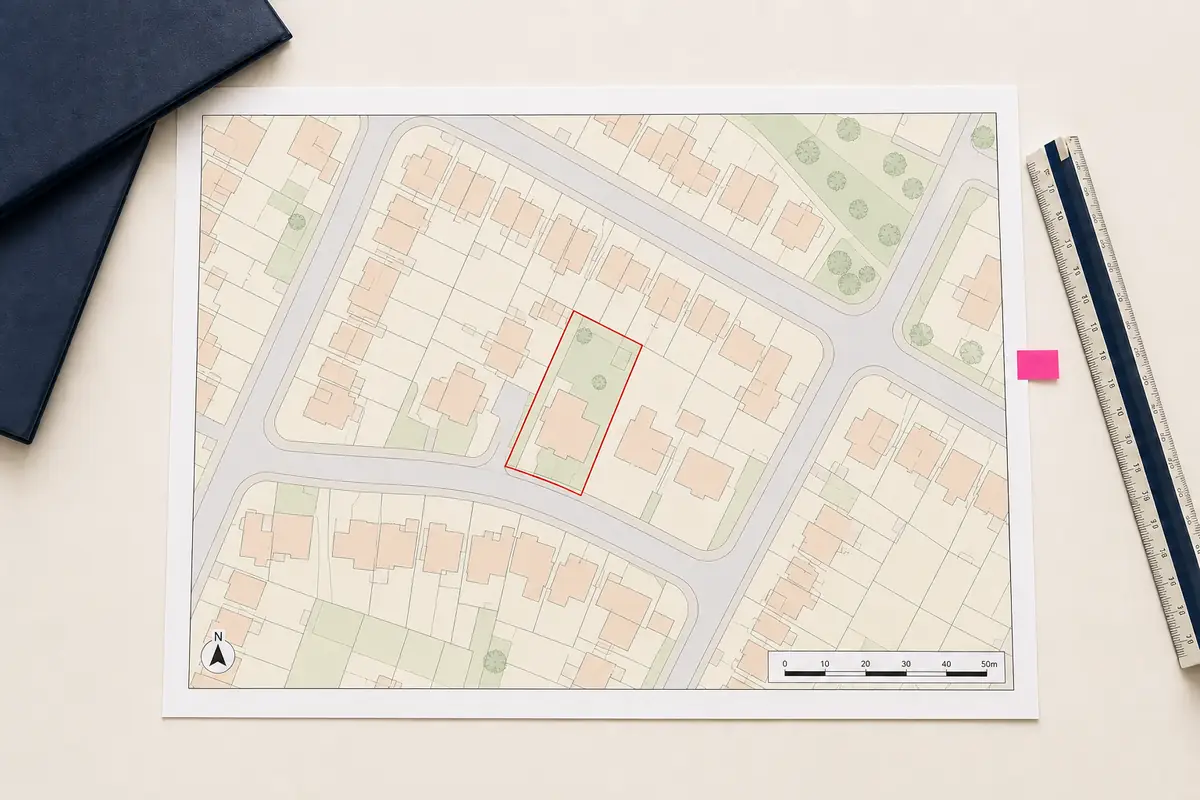
For many householder and small-site planning applications, a 1:1250 location plan is the usual starting point. It shows the application site clearly while leaving enough room around it for the council to recognise nearby roads, buildings and the general setting.
The number can look rather technical if you do not work with scaled drawings. In practice, the choice comes down to a simple question: does the plan show the site and enough of its surroundings clearly at the size you will submit?
This guide explains what a 1:1250 location plan scale means, when it is likely to be suitable and what else the finished plan needs to contain.
What does a 1:1250 scale mean?
At 1:1250 scale, one unit on the plan represents 1,250 of the same units on the ground. In everyday terms, 1 centimetre on the printed plan represents 12.5 metres in real life.
That relationship only remains accurate when the plan is viewed or printed at its intended paper size. If somebody shrinks an A3 plan to fit A4 paper, for example, it will no longer measure at 1:1250 even though the original scale label is still visible.
This is why a proper planning map gives the scale, paper size and other identifying information as part of the finished document. When printing a PDF, choose 100% or “actual size”, not “fit to page”.
What is a 1:1250 location plan used for?
A location plan helps the local planning authority identify the land covered by an application. It is not intended to show every construction detail. Its job is to place the site within a recognisable area.
At 1:1250, a typical residential plot remains large enough for a red boundary to be seen, while the surrounding streets and properties provide useful context. The scale is therefore commonly used for houses, small commercial properties and modest development sites in towns, villages and suburban areas.
Most planning applications also need a closer site plan or block plan. That separate drawing is normally prepared at 1:200 or 1:500 and shows the proposal in relation to buildings, access, boundaries and other site features.
The two plans answer different questions. The location plan says, “Where is the site?” The block plan says, “How does the proposal sit within it?”
When is 1:1250 the right choice?
A 1:1250 location plan scale is often suitable where the site is a normal-sized plot in a built-up area and the sheet can show enough surrounding detail for somebody unfamiliar with the address to find it.
It is likely to work well when:
- The application concerns a house, garden or small group of buildings
- The property sits among recognisable neighbouring plots
- One or more named roads appear within the map area
- The red line remains clear at A4 or A3 size
- The complete site, including any necessary access, fits comfortably on the plan
Do not select the scale simply because it is the most common option. Look at the preview and consider the site itself. A long access drive, a large field or an isolated rural property may need a plan that covers a wider area.
When might 1:2500 be more suitable?
A 1:2500 location plan shows a larger area of ground on the same sheet. This can make it a better choice for farms, country properties, extensive sites and places where the nearest recognisable road or building lies some distance away.
The trade-off is detail. Because the plan is more zoomed out, a small property boundary will appear smaller on the page. A scale that works well for a large rural site can make a standard urban plot unnecessarily difficult to see.
Choose the scale that gives the planning officer both a clear application boundary and enough context to locate it. If the council specifies a scale in its validation checklist, follow that requirement. If the site is unusual and neither standard option works well, ask the local authority or the professional preparing your application before ordering.
What should the location plan show?
The correct scale is only one part of a valid plan. A site location plan should normally be based on current, correctly licensed mapping and include a north point. It should show enough adjoining roads, buildings or other features to identify the site.
The application site should be outlined clearly in red. The red line needs to include all land required for the proposed development, which may include access from the public highway rather than only the building itself.
If the applicant owns other land close to or adjoining the application site, that land may need to be outlined in blue. The blue line is not a second border around the application site; it identifies other nearby land in the applicant's ownership that falls outside the red line.
Your finished plan should also state its scale and be set on a recognised paper size. Check the local planning authority's own validation checklist, as requirements can vary with the type and location of the application.
How much surrounding detail is enough?
Aim for a balanced view. The whole red-line site should fit with a useful margin, while nearby road names and buildings remain readable. For a site reached by a private drive, show the route to the public highway where it forms part of the application. Use the preview to move the map centre if the site sits too close to an edge.
A real example of why scale is worth checking
Scale mistakes do happen, particularly when a customer is preparing a planning application for the first time. In a review of UK Planning Maps, Miss Wray-Reynolds explained that she had chosen the wrong scale. She phoned for help and the plan was corrected within minutes.
That is a useful reminder to check before submitting, but it also shows that a wrong selection does not always have to become a long delay. If the preview does not show the area you expected, or the finished plan does not look right, get in touch rather than uploading it and hoping the council will accept it.
Common mistakes with 1:1250 location plans
Do not confuse a location plan with a block plan. Enlarging a 1:1250 map does not turn it into a proper 1:200 or 1:500 site plan; their purposes are different.
Other avoidable problems include:
- Drawing the red line only around the proposed extension instead of the application site
- Leaving the access outside the red line when it forms part of the proposal
- Forgetting a blue line around other nearby land owned by the applicant
- Cropping out the north point, scale information or useful road names
- Printing with “fit to page” and changing the stated scale
- Uploading a screenshot that lacks licensed mapping and document information
Always judge the whole page, not just the scale shown in the order form.
Check the finished PDF, not only the preview
Once you have downloaded the plan, open the actual PDF. Confirm that the red and blue boundaries are complete and that their lines do not cover important map features. Read the scale and page size, find the north point and look for enough surrounding context.
If you are submitting through the Planning Portal, upload the original PDF rather than a photograph or screen capture of it. If you need paper copies, make sure they are printed at the intended size and meet the mapping licence conditions. The UK Planning Maps help page explains the available file formats and common ordering questions.
Keep a copy of the finished map with the rest of the application documents. That makes it easier to check that the boundary shown on later drawings matches the location plan.
Choose the scale for the site in front of you
For a typical home or small urban site, a 1:1250 location plan gives a useful combination of detail and surrounding context. It is common for good reason, but it is not automatically right for every address.
Look at the size of the land, its relationship with nearby roads and how clearly the red boundary appears. Move to 1:2500 where a broader rural or large-site view is genuinely needed, and use a separate 1:200 or 1:500 block plan for close site detail.
Taking a minute to check the scale, page and boundary before ordering is much quicker than answering a validation query later. A good location plan should make the site easy to find at a glance. If it does that, and includes the required planning information, it is doing its job.
Ready to Get Your OS Plans?
Every plan is instantly downloadable, Planning Portal‑compliant, and includes all required elements. Get your plan now and submit your application with confidence.